A metropolitan-scale analysis reveals how walkable access to green spaces varies across Santiago’s neighborhoods, shaping everyday opportunities for wellbeing and equity.
One of the most significant indicators of urban wellbeing is accessibility to Urban Green Spaces (UGS). The way people rest, move, socialize, and breathe is influenced by parks, plazas, and small natural areas, but access to these spaces is often unequal in cities like Santiago.
This study uses the H3 Geospatial Indexing System, a contemporary spatial lens, to examine territorial differences. Analyzing Santiago through a consistent, multi-resolution grid reveals how proximity to green areas changes at different scales, from metropolitan patterns to the detailed realities of daily life. The goal is to not only quantify distance, but to uncover the geographic landscape of opportunities, highlighting areas where access to nature fosters health and a sense of community, and identifying gaps that may exacerbate environmental and social disparities.

In Latin America, the distribution of nature-based amenities is influenced by residential segregation and unequal public investment, which determines who reaps the benefits. The environmental opportunities in Santiago are closely linked to the city’s historical inequities and spatial structures. By using a unified spatial lens, we can uncover these disparities and place the city within the larger context of environmental justice discussions.
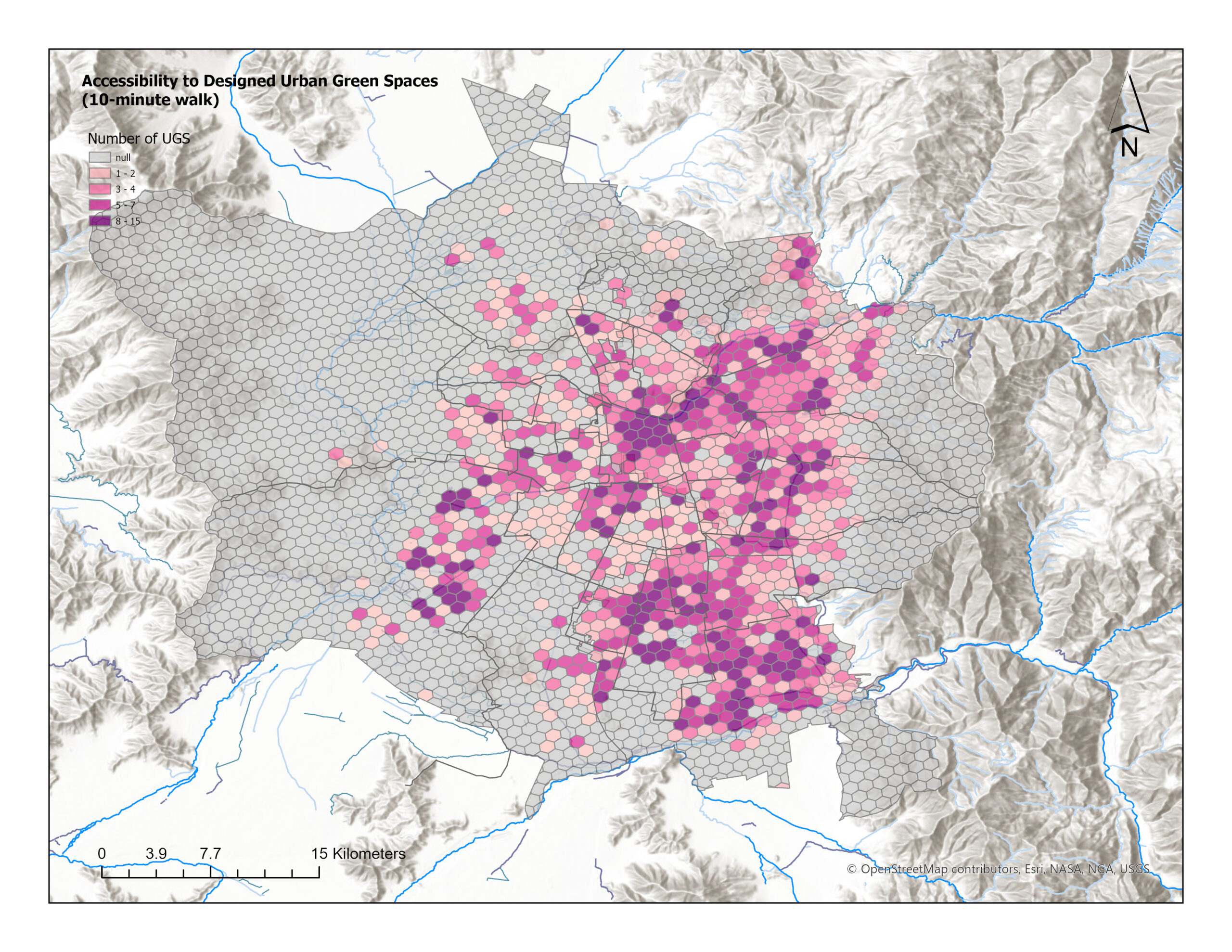
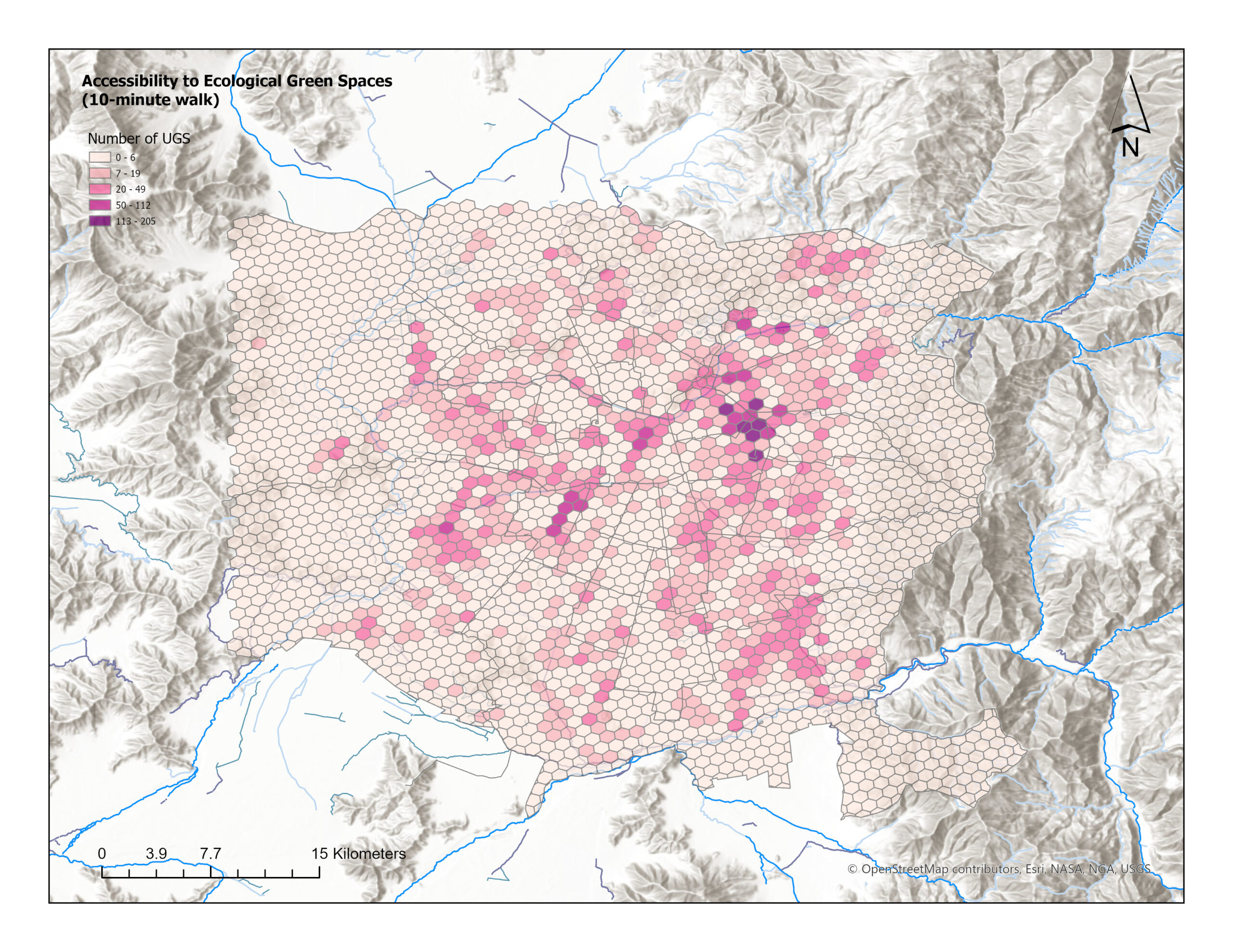
This analysis identifies two complementary categories of Urban Green Spaces (UGS), highlighting both the resident experience of the city and ecosystem functionality across the metropolitan landscape.
Publicly maintained green areas, designed to promote recreation, social life, and daily wellbeing, are planned for everyone’s benefit. The list includes parks, gardens, commons, nature reserves with developed facilities, recreational areas, and small pocket parks. These spaces offer accessible amenities, safe areas for socializing, and chances to unwind, stay active, and engage in community activities. They play a crucial role in shaping residents’ daily experiences of livability, as they represent investments and services provided by municipalities.
Landscapes shaped mainly by ecological processes, with minimal formal design and recreational infrastructure, are characterized by vegetation. The various landscapes featured include forests, meadows, orchards, grasslands, green fields, and basins. The value of these ecosystems lies in their ability to cool, maintain biodiversity, regulate stormwater, provide habitat continuity, and enhance landscape resilience. These areas, even with limited or informal public access, serve as the ecological foundation that sustains long-term environmental well-being.

Having access to nearby green spaces can foster healthier, more resilient, and stronger communities.
All datasets used in this study are fully open source, including Urban Green Spaces and Pedestrian Network, which was extracted from OpenStreetMap (OSM). Demographic data was retrieved from the Chilean Census, and UGS validation was cross-checked against official open data of Santiago and the Metropolitan Region.
All spatial analysis was performed using the SIRGAS 2000 coordinate system, Chile’s official geodetic reference frame, to ensure accurate, meter‑based measurements across the metropolitan area. Web‑based WGS84 layers were automatically adjusted to this projection for consistency.
The data processing workflow was centered on implementing the H3 hexagonal hierarchical indexing system at resolution 8, which was initially clipped to the Santiago administrative boundary. The UGS input layers were cleaned and standardized according to the study’s classification scheme.
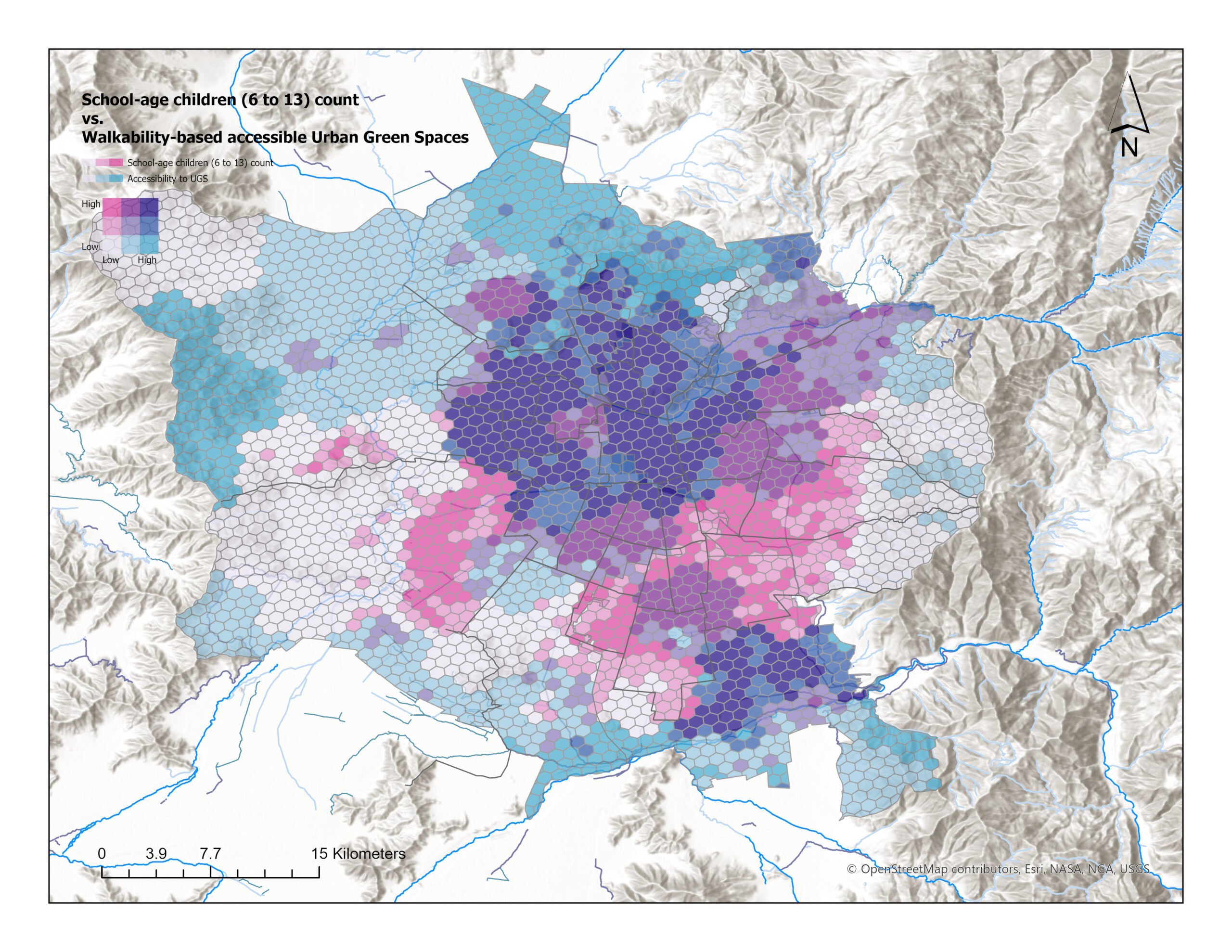
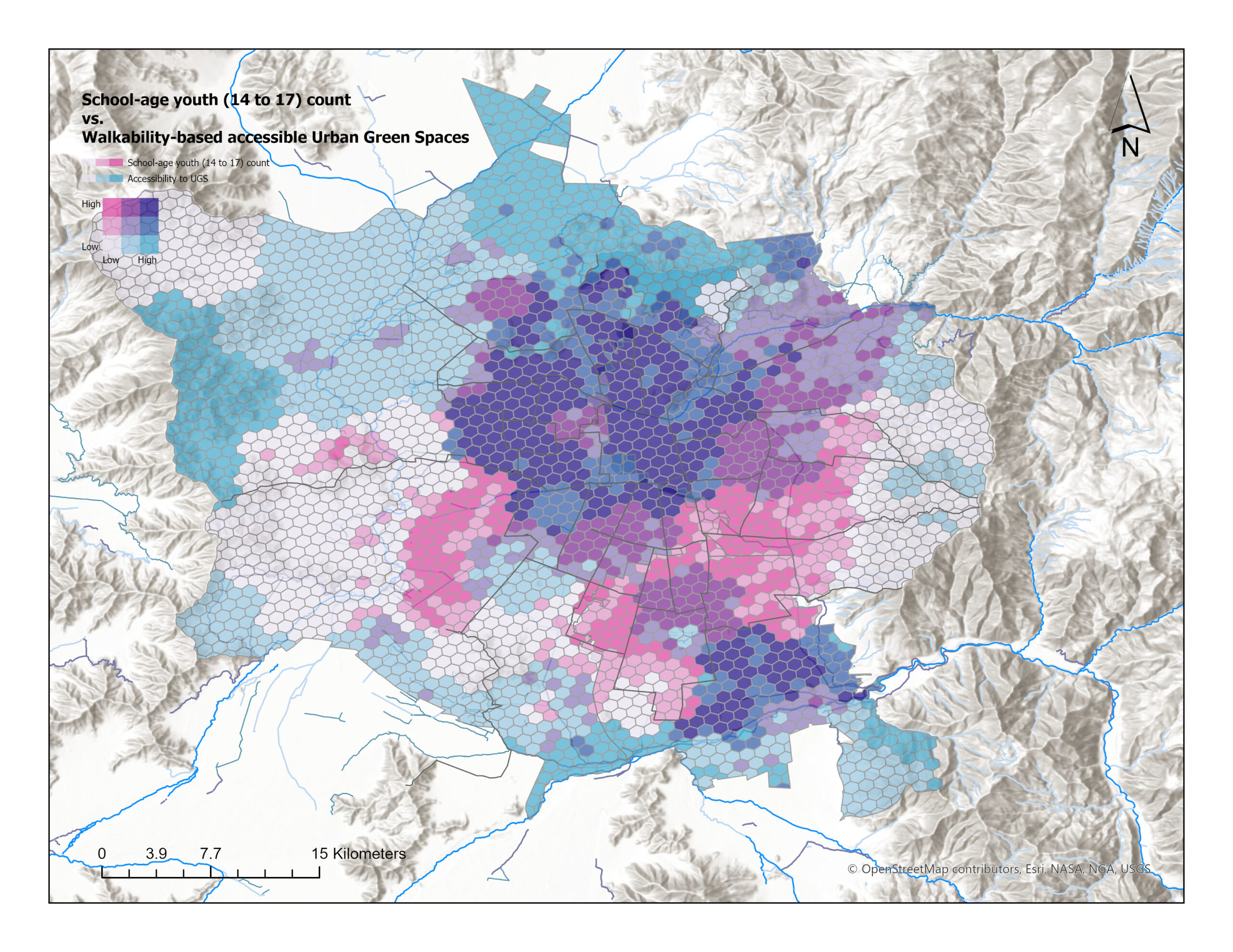
Population data was allocated proportionally by intersecting H3 cells with block-level census data. This enabled the calculation of demographic percentages for three key groups: School-age children (5–13), School-age youth (14–17), and Seniors (60+). This approach highlights how accessibility conditions intersect with age-based vulnerability.
The network‑based accessibility analysis was conducted using a pedestrian network built in ArcGIS Pro, integrating OSM pedestrian and road datasets.
This network accurately captures real-life walking conditions, featuring street connectivity, obstacles, crossings, inclines, and local pedestrian routes, with service areas defined as the 10-minute walking distance from the center of each UGS polygon.
The analysis shows a clear spatial divide exists:
The differences reflected are in quality, maintenance, safety, comfort, connectivity, and street-network structure. Vitacura, Las Condes, and Providencia’s communes are distinguished by their well-connected and high-quality green spaces.
La Pintana and similar vulnerable areas suffer from a lack of adequate green spaces, with smaller, fragmented, or poorly equipped parks that exacerbate environmental injustice, leaving residents more susceptible to heat, air pollution, and limited recreational opportunities.
Puente Alto, equally distant from Santiago’s center but more densely populated, boasts better access to urban green spaces, demonstrating how local planning decisions and investment priorities can lead to vastly different outcomes in adjacent areas.
Maipú, located to the southwest, boasts a significant amount of green space, which contributes to a more balanced distribution of environmental amenities in Santiago. Many green spaces, typically found in rural or peri-urban areas, are located beyond a 10-minute walking distance. Although they have high ecological value, these areas are limited in terms of walkable accessibility.
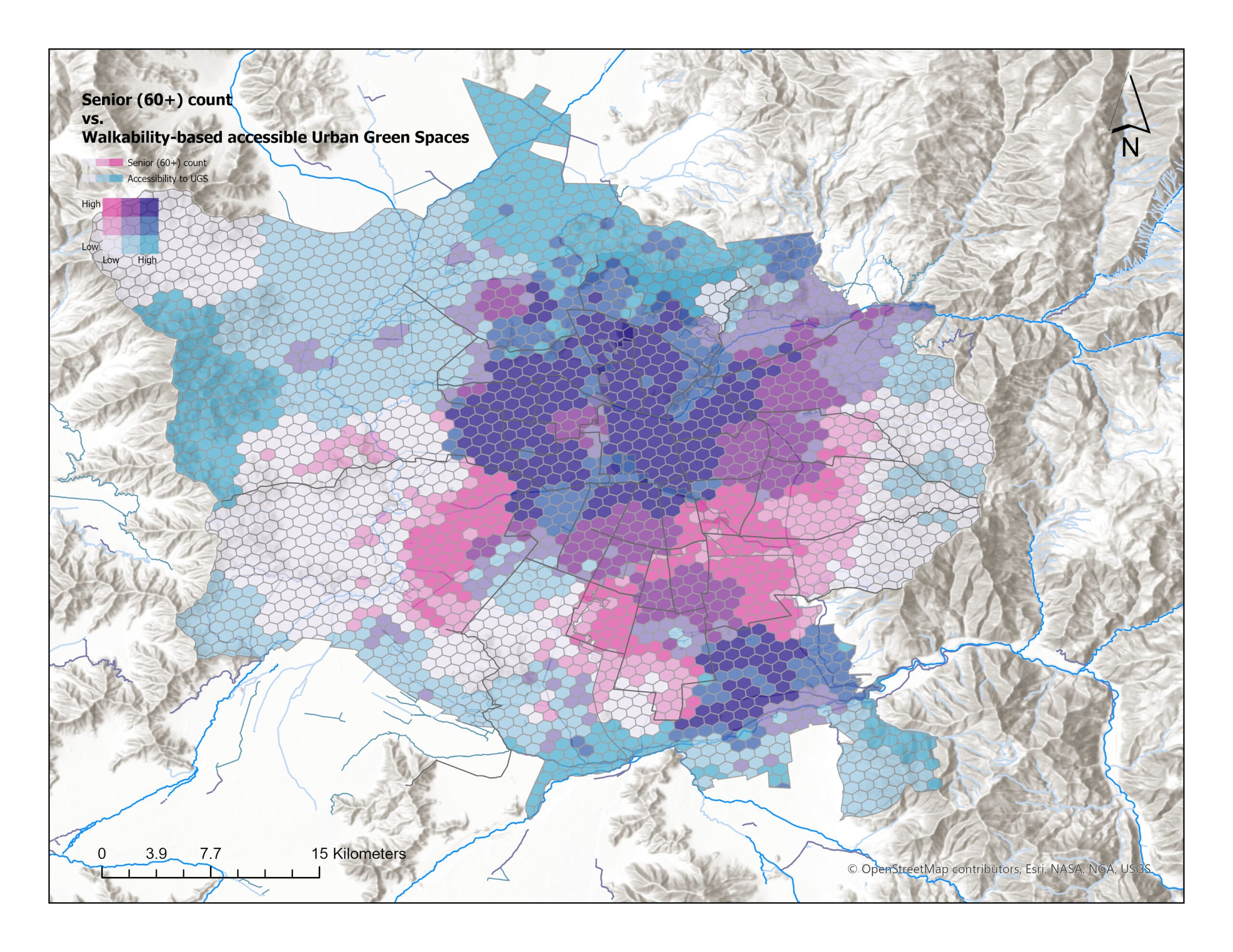
A similar spatial pattern appears when demographic concentrations are compared to accessibility. The study uses bivariate symbology to map the distribution of children, youth, and seniors alongside accessibility levels. This highlights the limited walkable access to Urban Green Spaces (UGS) experienced by vulnerable populations in certain areas.
The issue is not just about the number of parks, but also about the unequal distribution of opportunities due to the street network, urban layout, and past investment decisions.
To contextualize the accessibility results, this study compares green-space availability in two representative communes. Vitacura dedicates 14.8 m2 per person of its surface to urban green spaces, yielding some of the highest per-capita values in the metropolitan region. In La Pintana, green spaces cover only 3.1 m2 per person of the territory.
These values are derived from the most accurate spatial data currently available, acknowledging that some municipal inventories remain incomplete. Even under these conservative estimates, per-capita provision falls below the World Health Organization’s minimum recommendation of 9 m² per person. The metropolitan landscape reveals a clear divide: “garden-city” conditions in the northeast versus “urban green deserts” in the south and west. Accessibility is shaped not only by walkable distance, but also by the equitable distribution of green spaces across the urban area.
In Santiago, there are significant territorial disparities in terms of walkable access to urban green spaces. Residents of eastern and central communes enjoy the advantage of having multiple, high-quality parks within a 10-minute radius, providing ample opportunities for recreation, cooling, and socializing. In contrast, southern and western communes have smaller or poorly equipped parks, highlighting how urban planning, investment, and maintenance contribute to unequal access to opportunities.
The comparison of these patterns with demographic concentrations reveals that children, youth, and seniors in vulnerable areas consistently have limited access to green spaces, highlighting the fact that green-space distribution is a critical factor in both public health and environmental justice.
Promote territorial equity.

Enhance walkability and multimodal access.

Ensure coordinated metropolitan planning.
The findings reveal opportunities to promote territorial equity by investing in disadvantaged communes, thereby enhancing the quality, safety, and accessibility of local green spaces. Enhance walkability and multimodal access by improving sidewalks, crossings, lighting, and cycling connections. To ensure coordinated metropolitan planning, employ replicable and grid-based methods for monitoring accessibility. By implementing these measures, we can eliminate long-standing territorial disparities and guarantee access to nearby, high-quality green spaces for all residents.
This study identifies several promising avenues for improving access to green spaces in Santiago. By incorporating qualitative indicators like canopy cover, shade, safety, and park amenities, a more comprehensive understanding of everyday usability can be gained, going beyond distance-based measures. A broader understanding of reachability across the metropolitan area can be gained by expanding the analysis to include multimodal access, particularly cycling and public transport. The inclusion of heat-exposure and air-quality layers would enable an assessment of how green spaces promote climate resilience and environmental health. By incorporating updated OSM data and satellite imagery over time, continuous monitoring would be enabled, supporting evidence-based planning and more equitable investment across communes.

Measuring accessibility is not only a technical task, but also a means of envisioning more equitable urban environments.
By integrating open data, spatial analysis, and a nuanced understanding of territorial dynamics, investments can be strategically guided, neighborhoods prioritized, and policies designed to bring nature into closer proximity to daily life.
© 2026 Livable Urbs. All rights reserved.
The spatial analysis, customized visualizations, urban planning insights, and research presented on this website and related materials are the intellectual property of Livable Urbs. While base map data is sourced from © OpenStreetMap under the ODbL license, all modifications, interpretations, and added layers are proprietary to Livable Urbs. Spatial analysis was performed using ArcGIS Pro by Esri, and demographic data was sourced from the Chile National Census (INE). Any unauthorized reproduction, distribution, or commercial use without prior written permission is strictly prohibited.
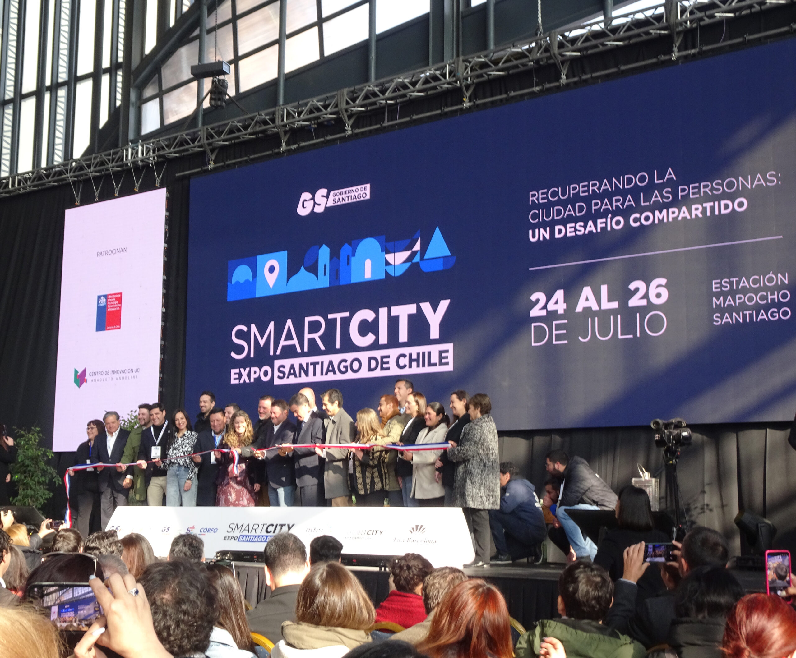
The Smart City Expo Santiago 2025 took place from July 24 to 26 at the Centro Cultural Estación Mapocho in Santiago, Chile, convening urban planners, policymakers, community leaders, and technology innovators from across Latin America and beyond.
The opening session set a powerful tone, reaffirming Santiago’s commitment to inclusive development, urban resilience, and the transformative power of public policy in shaping livable futures. This year’s central theme, “Taking back the city for people: a shared challenge” called for a renewed focus on reclaiming urban spaces to advance equity,
well-being, and sustainability.
In addition to the main event, four specialized forums delved into the interconnected aspects of livable urbanism, including Mobility and City Planning, Safe and Resilient Cities, Restoring Nature to the City and Living better.
The International Congress, organized by Fira Barcelona, featured keynote sessions, case studies, and collaborative labs, guaranteeing a dynamic platform for dialogue and knowledge exchange.