In today’s fast-paced world, the way cities are designed has a profound impact on our daily lives, shaping everything from our stress levels to our social connections. The concept of proximity, how close essential services, workplaces, and recreational spaces are, plays a crucial role in determining the livability of urban environments. When cities prioritize walkability and accessibility, they create spaces that foster well-being, reduce commute times, and strengthen communities.
Imagine a city where walking, cycling, and using public transport could account for most trips. The city of Copenhagen aims to optimize its infrastructure, including roads, cycle tracks, traffic lights, and public transport, to provide citizens and visitors with an easy and sustainable way to explore its neighborhoods. Copenhagen aims to make all trips within the city accessible on foot, by bike, or via public transport, and is nearing its target.
Rethinking Cities: A Future of Proximity and Community
The future of cities lies in bringing people and amenities closer together, rather than expanding highways. Picture a neighborhood where all your daily necessities, including work, groceries, parks, and healthcare, are within a short walking or biking distance. Imagine spacious sidewalks lined with trees, green areas that foster connection, and streets where kids can play safely, without the risks of traffic. Would life be less hurried? Would it be more fulfilling?
These ideas have been around for a while. Widely regarded as a pioneer in urban thought, Jane Jacobs, the visionary author of The Death and Life of Great American Cities (1961), made significant contributions to the field. She advocated for neighborhood-focused planning approaches, believing that cities flourish when designed to foster human connection and community, rather than prioritizing inflexible, large-scale infrastructure.
Jacobs denounced urban renewal projects that razed communities and dismantled the natural essence of city living. She proposed preserving existing neighborhoods and promoting gradual development instead. A thriving neighborhood, according to her, requires a mix of residential, commercial, and recreational areas, narrow streets that encourage socializing, and a dense population that supports efficient public transport and lively public spaces focused on human-centered design. Conversations around creating more inclusive, dynamic, and livable cities continue to be shaped by her legacy.
Proximity, Walkability and Livability: the Triad Shaping Modern Urban Environments
Walkable cities represent a new urban paradigm, as walkability is deeply embedded in our daily lives and closely tied to the proximity of essential services and amenities.
According to Jeff Speck’s General Theory of Walkability (2013), the level of walkability of an area is driven not only by ‘usefulness’ (i.e. the utilitarian gain of a walking trip to get from point A to point B) but also by the safety, comfort, and attractiveness of this walking environment. It is driven by a complex set of tangible characteristics including the physical infrastructure conditions, the level of network connectivity, high land-use mix, vitality and distinction of urban character.
Walkable environments play a vital role in supporting mental health and overall well-being. They promote daily physical activity, which can reduce stress, elevate mood, and enhance cognitive function. By encouraging spontaneous social interaction and access to green spaces, walkable cities help strengthen community ties and reduce feelings of isolation. These elements not only improve emotional resilience but also create healthier, more connected urban lives.
The 15-Minute City: A Revolutionary Urban Concept
While 20th-century urban planning often prioritized efficiency through zoning-based, car-centric models, separating residential, commercial, and industrial areas and connecting them via long commutes, the 15-minute city offers a radically different approach. It embraces proximity and mixed-use design, reimagining neighborhoods as self-sufficient hubs where daily activities like living, working, learning, and relaxing are all accessible within a short walk or bike ride. This human-scaled paradigm fosters local vitality, active mobility, and more sustainable, connected urban living.
As Professor Carlos Moreno explains, the emergence of the 15-minute city concept is deeply connected to the climate crisis, as it offers a practical response to the urgent need for low-carbon, sustainable urban living. By encouraging people to live, work, and access essential services within a short distance from home, this model reduces reliance on cars, cuts greenhouse gas emissions, and promotes more resilient, human-centered cities. It reframes urban planning as a tool not just for convenience, but for climate action and social well-being.
The Covid-19 pandemic worsened existing social and economic inequalities in cities, making problems like safety concerns, unstable housing, and unequal access to healthcare even more pronounced at the local level. The 15-minute city model addresses these challenges by reorganizing urban space into a polycentric system, where essential services, workplaces, healthcare, education, and recreational facilities are all within walking or biking distance, ensuring equal access for everyone. This strategy helps reduce emissions, stimulate local economies, and strengthen socio-spatial resilience.
Copenhagen: a Blueprint for Proximity, Walkability and Livability
Denmark’s capital, Copenhagen, is globally renowned for its exceptional walkability and accessibility, thanks to urban planning strategies that prioritize proximity, human-scale design, and inclusive mobility. The city’s design promotes walking and cycling by featuring a comprehensive network of bike lanes, traffic-calming measures, and well-maintained sidewalks.
Data-Driven Mobility. Strategic initiatives such as Walkwise Copenhagen have contributed valuable urban analysis tools to assess pedestrian conditions and inform ongoing planning efforts. These methodologies reinforce Copenhagen’s commitment to data-informed, people-centered urbanism.
Green for All. The city’s approach to green infrastructure also incorporates equity. The widespread access to public green spaces is intentionally designed to promote mental well-being and social inclusion, thereby ensuring that nature is accessible to residents of all income levels in their daily lives.
Mobility Without Barriers. Inclusive design is a hallmark of Copenhagen’s urban landscape. To promote mobility and autonomy, public infrastructure is designed to be accessible to people with disabilities and older adults, featuring barrier-free metro stations, tactile paving, and universally accessible public amenities.
Streets for People. From historic lanes to vibrant public spaces, Copenhagen offers a rich tapestry of pedestrian-friendly environments. Streets like Gråbrødretorv, Magstræde, and Snaregade exemplify the city’s human-scale design ethos. Superkilen Park is a prime example of innovation in public spaces, where pedestrian pathways are combined with cultural installations that celebrate the neighborhood’s diverse heritage. Kultorvet and Amagertorv, once central squares, have been transformed into thriving pedestrian zones, now bustling with public gatherings, markets, and cultural events.
Strøget Street Exemplifies Long-Standing Urban Commitment to Walkability.
The city council experimented with pedestrianization on this thriving commercial street in the 1960s due to rising automobile congestion. Initially, business owners and authorities resisted the idea, but a trial closure ultimately resulted in increased foot traffic, stronger community engagement, and boosted commercial success. As of 1964, Strøget was designated as a permanent pedestrian zone, eventually growing to encompass five neighboring streets. As the world’s largest pedestrian zone, it promotes economic growth, inclusivity, and community engagement. Although air quality improvements were limited, the street’s redesign has resulted in a substantial decrease in noise levels and now emphasizes safety and public space equity. The transformation of Strøget demonstrates the positive impact of pedestrian-oriented planning on urban life and local economies.
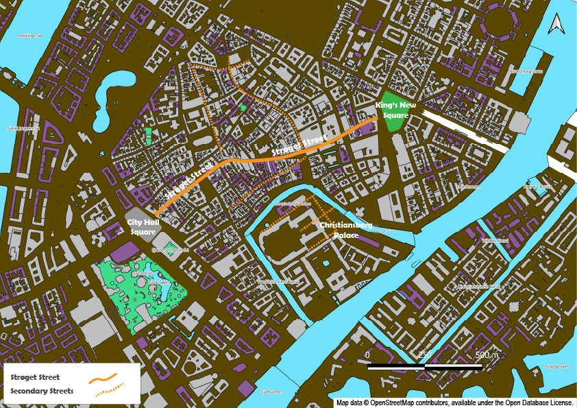
Strøget Main Street, Copenhagen, Denmark (Map development: HG)
Lessons Learned from Copenhagen
Copenhagen provides valuable insights into promoting sustainability and enhancing urban livability. To reduce reliance on private vehicles, the city focuses on developing green spaces, pedestrian-friendly areas, and a comprehensive cycling network, allowing residents to move around efficiently.
Globally recognized as a pioneer in sustainability, Copenhagen aims to become the world’s first carbon-neutral capital by 2025 (1). This ambitious goal is embedded in a holistic approach that places people and the environment at the core of urban planning.
-
- Gradual Change, Lasting Impact. Copenhagen’s success can be attributed to its gradual and adaptive approach to pedestrianization. Residents were able to adapt to new mobility patterns emphasizing cycling and public transportation by introducing change incrementally. Within a policy framework focused on human-centered development and inclusive urban design, these transformations took place.
-
- Mobility Targets with Purpose. The city’s long-standing commitment to sustainability is guided by three core objectives: reducing car dependency, expanding and improving metro services, and enhancing traffic management. The municipal plan reflects this ambition, setting a target for at least 75% of all trips, within, to, and from the city, to be made on foot, by bicycle, or using public transit. A complementary target limits car trips to a maximum of 25%.
-
- Seamless & Sustainable Connections. To address the increasing number of citizens, commuters, and visitors, Copenhagen has adopted sustainable mobility solutions to meet the growing demand. Designed to be mutually supportive, integrated transport systems, including buses, trains, and metros, facilitate smooth transitions between modes. In addition to this, considerable efforts have been invested in integrating cycling with public transportation, featuring bike parking facilities at stations and infrastructure that allows cyclists to transport their bicycles on trains and buses. The city’s connectivity was further enhanced with the launch of the M3 City Ring metro line in 2019, a loop line of the metro that connects the neighborhoods and the central station.
-
- Aligned Strategies for Equitable Access. Copenhagen’s accessibility is supported by efficient traffic flow and realistic travel time expectations, ensuring a smooth journey. The city has established service goals to ensure that cyclists, pedestrians, buses, and cars can reach their destinations quickly and efficiently, promoting equitable and functional mobility solutions. These mobility efforts are supported by a suite of interconnected policies, including the Mobility Analysis 2021, the Strategy for Carsharing 2017–2020, and the Action Plan for Green Mobility. Rather than operating in silos, these strategies are aligned and frequently reference one another, reinforcing a cross-sectoral commitment that drives sustainable, integrated change across the city’s administration.
-
- Close to the Goal. The city of Copenhagen strives to limit car trips to 25%, with the majority, 75%, being made by walking, cycling, or using public transportation. A 2021 Mobility Report reveals that Copenhagen’s modal share for all trips breaks down to approximately 31% by bicycle, 30% by public transport, 13% on foot, and 26% by car, bringing the city remarkably close to achieving its goal.
Copenhagen’s journey reminds us that meaningful urban change is not born from isolated interventions, but from a sustained, integrated commitment to livability, equity, and climate responsibility. Its gradual, human-centered approach to mobility, anchored in clear targets and supported by aligned strategies, offers valuable insights for cities worldwide. By embracing intermodal connectivity and prioritizing walking, cycling, and public transport, Copenhagen has crafted a model of proximity that is both functional and inclusive. Learning from such experiences allows us to adapt global lessons to local contexts, strengthening our collective ability to build cities that move with purpose and care.
(1) The city’s latest updates reveal a significant reduction in emissions, with a decrease of over 70% since 2005. Copenhagen stands out as a global leader in urban climate action, with a final assessment expected by the end of 2025.
Resources
Jacobs, Jane. (1993). The Death and Life of Great American Cities. Vintage Books.
Speck, Jeff. (2013). Walkable City: How Downtown Can Save America, One Step at a Time.
Moreno, Carlos. (2024). The 15-Minute CITY, a Solution to saving our time & our planet. Wiley.
Moreno, C., Allam, Z., Chabaud, D., Gall, C., and Pratlong, F. (2021). Introducing the “15-Minute City”: Sustainability, Resilience and Place Identity in Future Post-Pandemic Cities. Smart Cities 4(1), 93-111. Introducing the “15-Minute City”: Sustainability, Resilience and Place Identity in Future Post-Pandemic Cities
Walk Wise. Smarter Insights, Better Cities, Walkable Futures. Home | WalkWise
Global Designing Cities Initiative. Pedestrian Only Streets: Case study: Stroget, Copenhagen. Pedestrian Only Streets: Case Study | Stroget, Copenhagen – Global Designing Cities Initiative
Urban Development. Mobility-how we get around in the city. Mobility – how we get around in the city | Urban Development. Technical and Environmental Administration, City of Copenhagen.
Urban Development. The CPH 2025 Climate Plan. The CPH 2025 Climate Plan | Urban Development. Technical and Environmental Administration, City of Copenhagen.